

How to Read Tidal Streams Before Paddling: A Beginner’s Timing Formula
Why Understanding Coastal Water Flow Changes Everything for Paddlers
A tide chart can look intimidating when you are standing on a slipway with a loaded sea kayak. Numbers, arrows, height predictions and unfamiliar harbour names may suggest that tidal navigation belongs to professional sailors. In reality, you do not need complicated naval calculations to make better decisions. You need a clear picture of how water moves, a few reliable rules of thumb and enough discipline to check local conditions before launching.
This matters because a typical kayak cruising speed is only about 2.5 to 3 knots. A tidal stream of 1 or 2 knots can therefore make a major difference to your progress. It may turn a comfortable journey into a tiring slog, or carry you farther along the coast than expected. The good news is that tide knowledge for paddlers is less about heavy mathematics and more about timing, observation and sensible route planning. Once you understand the basics, working with the sea becomes a calm, almost meditative part of the journey.
The Vital Difference Between Tides and Tidal Streams
Start by separating two ideas that are often confused. A tide is the vertical rise and fall of sea level. It is why a beach may be covered at high water and exposed at low water. A tidal stream is the horizontal movement of water, carrying your kayak in a particular direction. The two are connected, but they are not identical. High tide tells you the water has reached a certain level, while the stream tells you where the water is actually travelling.
High tide does not automatically mean that the sea is still. In some locations, the strongest flow occurs around high or low water, while in others the current changes direction close to those times. Headlands, islands, narrow channels, estuaries and the shape of the seabed all influence the result. The National Oceanography Centre explains that local depth and coastline shape can significantly alter how predictable tidal movement is in practice. Learn these three terms first:
- Flood means the stream is generally moving landwards or towards the head of an estuary.
- Ebb means the stream is generally moving seawards or away from the head of an estuary.
- Slack water is the period when the horizontal stream is at, or close to, its weakest before changing direction.
Slack water is not always a motionless pause. It may last only briefly, and local eddies can continue moving even when the main stream has weakened. Likewise, a rising tide does not mean that every channel is flooding in the same direction. Check the stream atlas, local pilot information or a reliable current prediction for the exact stretch of coast. Tide times from a nearby beach are useful, but they may not provide the complete story for a narrow channel several miles away.
The Rule of Twelfths and the 50 90 Rule Made Simple
The Rule of Twelfths is a useful mental shortcut for estimating how much the water level changes during a standard six-hour rise or fall. It divides the total tidal range into twelve parts. During the first hour, approximately one twelfth of the range changes. During the second hour, two twelfths change, followed by three twelfths in the third hour. The pattern then reverses with three, two and one twelfth. This creates the familiar 1:2:3:3:2:1 sequence.
For example, if the predicted range between high and low water is 6 metres, the approximate hourly changes are 0.5 metre, 1 metre, 1.5 metres, 1.5 metres, 1 metre and 0.5 metres. This helps you estimate when a muddy foreshore may become passable or when a shallow landing could dry out. It does not predict current speed. For that, paddlers often use the 50/90 rule, which estimates instantaneous stream strength as a percentage of the maximum current.
| Tide hour | Approximate current speed | What the water is doing |
|---|---|---|
| Start of cycle | 0 percent | Slack water or very weak flow |
| Hour 1 | 50 percent | Flow building steadily |
| Hour 2 | 90 percent | Strong stream |
| Hour 3 | 100 percent | Near maximum flow |
| Hour 4 | 90 percent | Strong stream continuing |
| Hour 5 | 50 percent | Flow easing |
| Hour 6 | 0 percent | Approaching slack water |
These figures are approximations, not guarantees. The 50/90 rule describes current speed at points in the cycle, whereas the Rule of Twelfths describes water-level change. They should not be swapped. The shape of a real tidal curve may be uneven, and friction, wind, constricted channels and shoreline contours can all alter the timing. Use the rule to form a sensible expectation, then compare it with local current tables and what you see on the water.
A Four Step Launch Timing Formula for Relaxed Paddling
A good launch plan does not need to be complicated. It needs to answer four practical questions: when will the stream help, which way will it run, how strong will it be, and where can you land if the plan changes? Build those answers into your preparation before the kayak reaches the water.
- Check the primary port and calculate your window. Begin with the official tide station closest to your launch and destination. Government services such as the NOAA tide prediction station search show how important it is to select the correct station rather than relying on a generic regional forecast. In the UK, use the relevant harbour authority, Admiralty information or a well-established local tide service. Note high and low water, tidal range, sunrise, sunset and any likely wind changes.
- Identify flood or ebb along your route. Draw your intended route on a simple map and mark the direction that the stream will travel beside each headland, channel or estuary entrance. A flood may help you travel inland but hinder the return. In tidal rivers, the current can reverse direction over the course of the day, and shallow water may make some sections unusable at low tide.
- Choose slack water or use the weaker part of the stream. Beginners should aim to launch near slack water when possible, particularly near headlands, narrow passages and exposed crossings. If the route requires travelling with the stream, departing when the flow is around 50 percent of maximum can provide useful assistance without immediately placing you in the strongest water. Do not assume the most favourable tide time automatically makes the trip safe. Wind against tide can create steep, uncomfortable waves even when the current is helping.
- Set a ferry angle and identify a back-up landing. When crossing a current, point the kayak slightly upstream rather than directly at the opposite shore. This is called a ferry angle. A simple estimate is current speed divided by paddling speed, multiplied by 60. A 1-knot current against a 3-knot paddling speed suggests roughly 20 degrees, while a 2-knot current suggests roughly 40 degrees. These are only starting points, and the estimate becomes unreliable when current speed approaches your paddling speed. Keep paddling steadily, watch your actual track and be ready to alter course. Before launch, identify a sheltered beach, slipway or shoreline exit in case fatigue, weather or current makes the original landing unsuitable.
Keep the plan conservative. A route that works on a calm neap tide may feel entirely different during a spring tide, when the tidal range and stream can be much greater. Leave extra time for rests, navigation checks and an unexpected wait for conditions to ease. If the current is clearly stronger than expected, stopping in a safe eddy or turning back early is sound seamanship, not failure.
Reading the Surface Signs Along the Coastline
Charts and forecasts are essential, but the sea also gives you immediate information. Watch fixed or slow-moving objects before committing to a crossing. Lobster pot buoys, navigation marks and anchored boats reveal the direction of flow when you compare their position with a fixed point on shore. A buoy leaning hard to one side, a boat lying at an angle to its anchor line or foam moving consistently past a rock can all confirm that the stream is active.
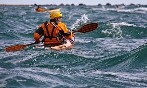
- Eddy lines form where fast-moving water meets slower water, often behind a headland, rock or island. They may provide a calmer place to pause, but the boundary can be turbulent.
- Tide rips and overfalls appear where current accelerates over shallow ground or collides with opposing water. They can create breaking waves and should be treated seriously, especially in a loaded touring kayak.
- Backwaters and calm bays may offer shelter from the main stream, although the entrance and exit can contain strong eddy lines.
- Water colour, foam and floating debris can show convergence zones and the general direction of surface movement.
Never use surface appearance as the only safety check. Smooth water may still be moving quickly, while rough-looking water may simply reflect wind. Coastal safety advice also emphasises checking tide information before visiting the shore and contacting the Coastguard through 999 if someone is in serious difficulty. Cold water, changing weather and limited landing options remain hazards even on familiar routes.
There is a wider benefit to learning these signs. When you stop treating the coastline as a static view and begin noticing its moving patterns, paddling becomes more attentive. Your breathing settles into a steady rhythm, your decisions become less rushed and the journey feels less like a battle against the sea. That mindful awareness supports the physical benefits of kayaking, including gentle endurance work and improved balance, while also giving the mind a useful break from screens and routine.
Step Onto the Water with Complete Confidence
The key mental shortcuts are straightforward. Use the Rule of Twelfths to estimate changes in water level. Use the 50/90 rule to form a rough picture of current strength. Then check the actual local stream prediction, determine whether the water is flooding or ebbing, and plan your launch around slack or a manageable flow. Add a ferry angle, a reserve landing and enough daylight, and a daunting chart becomes a practical decision-making tool.
Practise on a calm local estuary or sheltered bay before tackling an exposed headland. Pick a short route, write down the predicted stream times and compare them with what happens around your kayak. That simple habit will sharpen your judgement quickly. With preparation, observation and a willingness to turn around when conditions demand it, tidal paddling becomes more than a technical skill. It becomes a way to move with the ocean rather than against it, conserving energy and leaving you with a clearer head when you return to shore.
Comments Comments: 0
Comments are closed.